TrainsHistoryObservationsHumorAdvertisementsEventsMuseumsPhotosVideosTuesday ToursPost ArchivesHistorical ArtifactsPanorama ProjectRSS FeedFollow us on twitterSubscribe by emailHome

Posts Tagged ‘shore line east’

Tuesday Tour of Metro-North: A new system map Train

Tuesday, January 1st, 2013

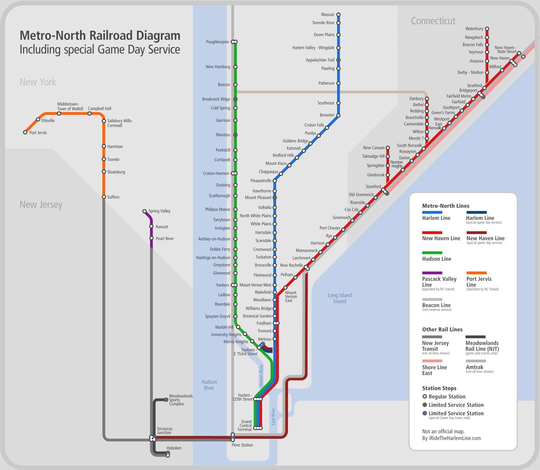
By now you are probably aware that I finally finished my three-year-long project to photograph every Metro-North station – all one hundred and twenty three of them. For my “final” Tuesday Tour post, I thought it would be nice to post a map which links to the photographic tours of every station. Though I’ve tried my hand at doing some Harlem Line maps in the past (they were crappy) and made an acceptable stab at a map of the West of Hudson Lines, I never really attempted a system-wide map. I’m not the biggest fan of Metro-North’s maps, especially how they deal with multi-line stations like Fordham (admittedly, it is not a bad map when you compare it to this atrocious Metro-North publication!), so I wanted to do something drastically different.

I guess when I say drastically different, I mean cleaner, hopefully easier to read, and showing info that the official map does not contain. One addition was Metro-North’s extra services, namely game/special event trains. Including them explains visually how Metro-North’s main lines connect, something most railfans probably know, but the average rider may not. The official map doesn’t properly illustrate that the Harlem and New Haven Lines run side by side up to Woodlawn, that they can both head onto the Hudson Line for Yankees games, or that the New Haven Line can diverge and follow Amtrak’s path into Penn Station and Secaucus for football games. Other additional info I included are limited-service stations, and shared stations. A handful of Metro-North’s stations also have Amtrak service, and in the case of New Haven station, Amtrak and Shore Line East service.

In all, my map is more of a “diagram” than anything. Some geography has been compromised a little bit for easier viewing and aesthetics. But every station name and dot links directly to its respective Tuesday Tour full of photos and history, so it is certainly an interesting way to see the system as a whole. Since the map is large, it will open in a new window. Click the preview image below to launch the map!

Metro-North Map Preview

In terms of plans for this year, now that the Tuesday Tours are finished (since you all seem dying to know), I think I want to go back to my roots. That means revisiting the Harlem Line. I know that some of you don’t really like this idea, or think it would be redundant – nonetheless, I don’t think I can legitimately call this site “I Ride the Harlem Line” and have such a poor showing in terms of station tours. For example, compare the first Tuesday Tour of Wassaic to the final one of Poughkeepsie. Wassaic’s tour contains 11 current day photos. Poughkeepsie’s had 37 current day photos, 15 historical photos, and a wide array of historical tickets and timetables. In other words, there really is no comparison. Plus it will be interesting to revisit several stations – Fordham was renovated since I was last there, and it would be super cool to not get the cops called on me when I go back to Melrose! Anyways, look forward to an updated tour of the Harlem Line later on this year!

Where are the trains? Train

Monday, October 3rd, 2011

Hello, and welcome to planet Earth. The Earth is a planetary body that revolves around the sun… unless you are one of the many Metro-North riders that have the erroneous belief that the world actually revolves around them. Those special people are known to cause scenes on the morning train (like the woman I saw last week yelling, “for every minute we’re late I’m docked pay!”), and somehow have the strange belief that Metro-North has one train running on each line: their train. The remainder of us, however, are well aware that the busiest commuter railroad in the country certainly has more than 3 trains running at a time. But how many? And where are they?

I had a kind of silly idea – I would create a map that showed the location of every Metro-North train at an arbitrary time during the morning rush. That way people would be able to really visualize how many trains there are, and to understand that they aren’t alone on the rails – not by a long shot. The map would provide a quick snapshot of what exactly is happening on every weekday morning. Somehow along the way the map turned into a little bit more interactive of a piece – using Google maps, one can zoom in and out, pan, and click on each train placemark for more information. Then I got a little bit more crazy – I added in the Shore Line East and Amtrak trains passing over Metro-North territory, as well as the deadheads I was aware of. If anything, there could be more trains than what are currently shown, but for the most part it is fairly exact.

If you click the above image, the interactive map should open in a new window. You can click any train placemark for more information. Any train deadheading (moving from one place to another, but not carrying passengers) will be labeled “not in revenue service.” You can also toggle on and off the various lines to, for example, show only Harlem Line trains. By default all trains are turned on – and there are quite a lot of them. Did you realize there were quite that many? Perhaps the subtitle of this map should be “RTC’s are awesome and I salute them.”

I must thank Eric (@kc2hmv) for doing quite a bit to help me get this map looking awesome, as my programming skills are nonexistent (the toggle feature was all him!). Secondary thanks goes to this site, as I based the design of my map off of the clean and nicely done commuter map found there.