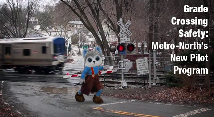
I Ride the Harlem Line - HomePosts about the trainPosts about observationsHumorous postsPosts about advertisementsPosts about eventsPosts about eventsPosts about museumsPosts with photosPosts with videosPost ArchivesRSS FeedTwitterYouTubePanoramio

Posts Tagged ‘valhalla’

Sending Postcards from the Harlem Line (Part 6) Train History Photos

Monday, December 19th, 2011

It has been a while since I last posted some old postcards… so I figured we were due for an update. Two of the cards we’ve seen before, though these are alternate views and in color. And even though some of them are not necessarily railroad related, it is interesting to check out the landscape as it once was. The Wassaic House, right alongside the railroad tracks, is visible in the second postcard of the set. Built in 1851, the Wassaic House was a hotel owned by wealthy local Noah Gridley. Gridley was also a financial backer for Gail Borden’s milk condensery, which in addition to the railroad and Gridley’s own iron works, were the three most influential industries in the history of Wassaic.

Other lovely cards that show the world around the rails is an example from Pawling, with the lake visible alongside the tracks. There is also a nice view of what the village of Valhalla looked like – the train station is partially visible on the left side of the card. And the grade crossing in Bronxville, with the funky old-style railroad crossing sign is a nice old view.

My favorite card of the bunch, however, is the nicely detailed shot of Brewster station. It is the same station we know and love, with some different details – like the New York Central Railroad stenciled above the door. You can click here for a comparison shot of Brewster today. The card of Brewster was sent in by reader Steve Swirsky, a contribution which is much appreciated!


Because you can never get enough postcards, there will certainly be more a 7th part and beyond. You can also check out the old parts, in case you missed any, with the following links:
Sending Postcards from the Harlem Line, Part 1
Sending Postcards from the Harlem Line, Part 2
Sending Postcards from the Harlem Line, Part 3
Sending Postcards from the Harlem Line, Part 4
Sending Postcards from the Harlem Line, Part 5

Views of Kensico Cemetery Train History Photos

Friday, September 9th, 2011

Dear readers, I am certain you are all acquainted with my terrible eBay habit. Lots of the old timetables, photos, and postcards find their way onto this site at some point in time. I must admit though, I love old things. Specifically, old paper things. Maybe it is because I am a graphic designer, and I love looking at old printed art, especially on pre-1900′s timetables and books. Though it is also possible that I’m just a nutjob destined to be one day featured on the show Hoarders. Either way, today I do want to share with you all my most recent acquisition, which is a little bit different than most things I come across on eBay.

If you’ve ever taken the Harlem Line north of White Plains, and past Valhalla, you are most likely familiar with the large cemetery that dominates the view in between stations. Kensico Cemetery shares a nearly mile-long border with the railroad, and astute observers can glimpse the main cemetery office, which once served as a railroad station, on the west side of the tracks. The choice of location of the cemetery isn’t hard to figure out – it offered both a beautifully rural final resting place, and was easily accessible from the city by the railroad. In fact, on the cemetery’s Board of Directors was Chauncey Mitchell Depew, whose name might be familiar, as I posted about him in April. He got his start as the legal counsel for the New York and Harlem Railroad under Commodore Cornelius Vanderbilt, and eventually worked his way up to the presidency of the New York Central – conveniently the railroad running right alongside the cemetery. Not only did the cemetery have its own private railroad station, it also had a private railcar named Kensico which could be rented for funerals. In 1910, the rental price for a locomotive with the railcar Kensico attached was $60.00, which today seems like a paltry sum.

All of these things I’ve discovered about the Kensico Cemetery were gleaned from a little hand-bound booklet printed in 1910, titled “Views in the Kensico Cemetery.” I bought the thing just for the single photo of Kensico station, and after flipping through it, I’m glad I did. I love it for the silliest reason, too – at the time of printing, the United States used three-digit phone numbers. There are plenty of things that I don’t really think about, and anything but seven-digit phone numbers are one of them (despite the fact that I know Brazil uses eight digits for cellular numbers, and don’t even get me started about their downright bizarre method of placing long distance calls). The book is chock-full of photos of the cemetery with plenty of open land, a much different view than today’s cemetery with over 130,000 “residents.” Below you’ll find a few of my favorite parts of the booklet, including the photo of Kensico Station.

Metro-North and the Aftermath of Irene, Damage Photos Train Photos

Sunday, August 28th, 2011

Edit: Metro-North has resumed most service. For the most current information, check the MTA website.

Mayor Bloomberg’s press conference addressing the damage after Irene has just completed. Of course, Chairman of the Metropolitan Transit Authority Jay Walder was present to address the state of New York City’s transit system. The unfortunate news for Metro-North riders is that it was our railroad that suffered the most damage out of all of the MTA. Walder said there was severe damage to all three lines, including significant flooding and track erosion. Damage assessments are still going on, and there will be no decision on when service will be restored until these assessments have been completed.

What I must say, however, is that MTA has been keeping us in the loop via their Flickr account, which is much appreciated. From the photos we can see that there is severe flooding at Tuckahoe and Valhalla, on the Harlem Line. Valhalla also has power lines down, in the vicinity of Kensico Cemetery. There was a mudslide at Spuyten Duyvil and Scarborough on the Hudson Line. Beacon, also on the Hudson line, has massive flooding and is probably the worst station I’ve seen so far, with the parking lot and pedestrian underpass completely filled with water. Harriman, on the Port Jervis Branch also has a flooded parking lot. Thus far there has been no photos posted of the New Haven Line, but Governor Dannel Malloy has said that there was extensive damage to the catenary system, and on the New Canaan branch. I’ll let the pictures speak for themselves… (all photos credited to the MTA)


Also interesting are a few photos from yesterday in Grand Central. Seeing the station this empty is a bit creepy. Although people say that this happens quite frequently at night, it is obvious that it is not night in these photos. You can see Grand Central Terminal empty – with the sunlight still streaming through the windows. That light makes these images even more amazing to me. I’m a bit jealous I wasn’t there myself to take photos of the empty station!


The Harlem Line, in panoramas Photos

Thursday, February 3rd, 2011

I’ve spent many months posting various panoramas of the Harlem Line stations. I’m now excited to be able to post the entire Harlem Line, viewed in panoramas. You can watch as the farmland and rural greenery morphs into the suburbs, before changing into the concrete jungle of New York City. If you want to see more photos from each of the stations, just click on the picture. Anybody have a favorite panorama? I think my two favorites are Tenmile River and Harlem-125th Street – the two of them are polar opposites in terms of the scenery visible while taking a ride down New York City’s oldest railroad.

For those who like maps, I place all of my panoramas on a Google map, which you can see below. I also add photos to Panoramio, which provides the photos for Google Earth.

View larger map

Me at Every Harlem Line Station Train Photos

Monday, November 22nd, 2010

Many months ago I began a little project to take a panorama at every Harlem Line station. I am exceptional at beginning projects, yet terrible at completing them. However, this is one project that I will finish. I have now been to, and photographed, every Harlem Line station. After I had decided to actually do this, the first station I photographed was Tenmile River (on May 24th), and the last was Williams Bridge (on November 21st).

Keeping to the schedule of a posting a new station every Tuesday, it will still take another month or so to complete the project publicly. But today I will post the “Hall of Fame” – me in front of the name sign at every station. While I am on the subject of the stations though, I’d like to thank Eric for accompanying me to most stations south of White Plains, my mother, who has now been to every station north of Bedford Hills, and Despina who joined me at Valhalla, Mount Pleasant and Hawthorne.

Tuesday Tour of the Harlem Line: Katonah Train Photos

Tuesday, September 21st, 2010

By now my little photography adventures have taken me to almost all of the Harlem Line stations (the only outstanding stations are Woodlawn, Williams Bridge, Botanical Garden, Melrose and Tremont. I’ve been warned for my safety at the last two). I’ve done a lot of fun things, and gotten to explore quite a bit. I’ve eaten an italian ice in Hartsdale with @kc2hmv, splashed in the river near Crestwood, and munched on good food in Mount Kisco, Valhalla and Tuckahoe. I’ve seen all the Arts for Transit pieces, and other randomly cute things, like the Commuter Rooster in Scarsdale. But despite all this, when I chatted with @bitchcakesny last night and she asked me my favorite station of all, I couldn’t quite answer.

There are so many good things about some of these stations, how could I pick just one? Wassaic and Pleasantville have my favorite Arts for Transit pieces, and I loved Harlem-125th’s art too, not to mention it was a great spot for photography. Bronxville has a unique station, and the shops surrounding Mount Kisco, Hartsdale and Scarsdale are cute and worth exploring. Chappaqua’s restored station building is a beautiful sight, and I’ve always been fond of Brewster’s old station building. What I was able to do though, is narrow it down by asking myself a question: If I had to be stuck at a single station for the entire day (maybe there was a big fire or something, shutting down Metro-North??), which would it be? And that answer is Katonah.

What makes Katonah special? The area around the station is very cute – full of shops and restaurants for eating good food. I will admit though, the Katonah Museum played a part in the decision. If you don’t mind walking the half mile from the station to this art museum, you really could spend the entire day here viewing art, shopping and eating. And if there was still time left you could hang out in the gazebo not far from the station, or go and visit the library which is two blocks away. Katonah is just another one of the nice places located along the Harlem Line, but one that certainly sticks out in my mind.


Nature along the Harlem Line: The Muscoot Reservoir & Bridge L-158 Photos

Friday, September 17th, 2010

I thought it might be fun to do something different this Friday… Tuesdays I visit train stations, but I don’t talk much about what else is around the station. The Harlem Line has plenty of intriguing spots along the route, and many for the nature lover. I do get emails every once and a while asking me questions about doing things – people wondering what is within walking distance of the stations, and what they can get away and do. And for those who, like me, do not drive, or don’t feel like driving, you can definitely take Metro-North to get to interesting spots.

As I mentioned, there are many nature-related locales on the Harlem Line. Some of the obvious ones are the Botanical Garden and the Appalachian Trail, but there are many lesser-known spots. Pawling has the Pawling Nature Reserve, which is not far from the Appalachian Trail. At the end of the line in Wassaic is the trailhead for the Harlem Valley Rail Trail which follows the old route the Harlem Line once took further north. Lower Westchester has the Bronx River Parkway Reservation which is more than 13 miles long and stretches from Valhalla to Bronxville – and passes by North White Plains, White Plains, Hartsdale, Scarsdale, Crestwood and Tuckahoe stations.

One of the lesser-known spots is near and dear to my heart, situated in Goldens Bridge and not far from my house. In the evenings it is here that I make laughable attempts at running off the past nine years I spent sitting on my ass in front of a computer. In all seriousness though, it is beautiful and quiet little spot that few people other than fisherman and neighborhood residents (and some deer, swans and bullfrogs) know about. The trails are not extensive, but they surround the beautiful reservoir and provide access to various fishing spots. I went one step beyond that and purchased a boat for use on the reservoir as well (boat use is heavily regulated, this is NYC’s drinking water, after all). However, the most noteworthy part of this “Public Access” DEP area is the old railroad bridge.


I created this map based on my own explorations of the area. Maps are actually fun to make. :P

I’ve mentioned Bridge L-158 a few times before. It is one of the few remaining vestiges of the branch of the Harlem Line that ran from Goldens Bridge to Lake Mahopac, and is on the National Register of Historic Places. It was originally built in 1883 over Rondout Creek near Kingston, NY, but was moved in 1904 by the New York Central Railroad to Goldens Bridge. Although the original bridge carried two tracks, the Mahopac branch was a single track line and when the bridge was reconstructed the width was shortened for a single track.


If you’re interested in visiting this part of the Harlem Line, it is within walking distance of Goldens Bridge station. Although it is rarely enforced, you do need an access permit to use the land for recreational use. But access permits are easy to get – you can register for one online and print it out immediately. If you’re interested in fishing or boating, you’ll need additional permits, so I advise checking the DEP’s site. People fish in the reservoir all year long, as the Muscoot is one of the reservoirs in which ice fishing is permitted. Although it is a lot smaller than some of the other nature spots around it is at least worth visiting to see the historic bridge. There are some times where it gets so quiet, except for the crunching leaves under the foot of a squirrel or deer, that you forget that you’re not that far from the city… only until you hear a train go by, yanking you back to reality.

Tuesday Tour of the Harlem Line: Valhalla Train Photos

Tuesday, September 14th, 2010

When I was a lot younger if you had asked me what my favorite train station was, I’d probably say Valhalla. I had never been there, but every time I rode the train and we passed it by, I thought Valhalla was the coolest station ever. You see, I was always a fan of Norse mythology (and if you were wondering, Loki is of course my favorite Norse god). I also loved this silly old game called Castle of the Winds, which I played on my computer that had Windows 3.1 loaded on it. Castle of the Winds was roughly based on Norse mythology. And if your character was to die at any point during the game, your name would be listed on a scroll: Valhalla’s List of Legends.

Usually the quick response given to anyone wondering what exactly Valhalla was, is that it was Heaven in Norse mythology. But calling it Heaven doesn’t fully explain the subject. Valhalla was the hall of slain warriors. Warriors that died in battle congregated in Valhalla with the chief god Odin, awaiting Ragnarök (battle at the end of the world). During that battle, these warriors would fight alongside Odin. The real question that comes to mind though, is how the heck did a little hamlet in Westchester county come to be known as the Norse hall of slain warriors?

The story (whether it can be validated or not, I am unsure) is that after the village of Kensico was flooded (for building the dam) the relocated people and their post office needed a new name for their town. The postmaster’s wife, who was a fan of Wagner, chose Valhalla. One of Wagner’s operas is titled Ride of the Valkyries, the Valkyries being those who transport the deceased warriors to Valhalla. Considering the hamlet is well known today as being the resting place of many people, with all its large cemeteries, I bet that woman thought she was pretty sly.

Technically the blog has visited Valhalla already – at least the old station building, which is a restaurant, and back in February I made a snow angel on the platform there. But this time I am officially visiting the station itself (and in good weather!), and in typical Tuesday fashion, have quite a few pictures.


Valhalla’s Kensico Dam: Photos and History History Photos

Tuesday, May 4th, 2010

The next time you find yourself on a Metro-North train going past Valhalla Station, be sure to take a look out your window, facing eastward. You’ll be able to catch a quick glimpse of the Kensico Dam as the train goes by. The dam holds back the waters of the Kensico Reservoir, the primary source of water for the city of New York. The 98-acre grounds around the dam are a county park called the Kensico Dam Plaza. While the weather was warm last week, I took the opportunity to have lunch at the park, and of course I took lots of pictures. Kensico Dam Plaza is one of the many interesting places to visit in the area within walking distance of Harlem Line stations (In this case, Valhalla). In addition to the dam, the grounds also contains a September 11th Memorial, called The Rising, designed by architect Frederic Schwartz. The memorial lists the names of all one hundred and eleven Westchester County residents that died in the attacks.


The original Kensico Dam was built in 1885 and created a small lake with water from the Bronx River, as a source of water for New York City. As the city expanded, the dam could not fulfill the city’s need for water, and was eventually expanded. This expansion required the land from the village of Kensico, and so the property of the entire town was purchased to make room for the new dam. The former town now rests underwater, covered by the now larger Kensico Reservoir. This larger reservoir receives water from other reservoirs in the Catskill Mountains, through the ninety-two mile Catskill Aqueduct.


Old diagrams of the Kensico Dam and grounds, the plan of the grounds does not appear to match with what is there now. The plans were modified, or the grounds were changed later on.


Construction photo of the dam

Construction for the new Kensico Dam began in 1909, and the project employed more than 1500 workers. Workers earned an average of one dollar and twenty-five cents per day. Railroad tracks were built for the purpose of removing earth from the site, as well as moving building materials. The main building material used in the dam is concrete mixed with large stones, called Cyclopean concrete. The dam face is made of large granite stones from a quarry in nearby Cranberry Lake. Kensico Dam measures 300 feet high, and 1830 feet long. There is a road that runs over the top of the dam, though it has been closed since the September 11th attacks. The grounds that form the Dam Plaza and county park total 98 acres, and are used for picnicking, running and walking, bicycling and more. The ice cream man also makes frequent visits during the summer months, and if you’re lucky you’ll get both the Good Humor man, and the Mr. Softee man. And who doesn’t like ice cream?

The Loneliest Station on the Harlem Line Train Photos

Wednesday, April 21st, 2010

Nestled in between the stations of Valhalla and Hawthorne on the Harlem Line is an active station that you might not be aware of. Most trains pass by without stopping. On weekdays, only one train in each direction makes a stop there. On weekends there are three. The station is Mount Pleasant, and it just might be the loneliest station on the Harlem Line. The only other station that could arguably take the title is Appalachian Trail, which is north of Pawling and in diesel territory. That station does not get any trains on weekdays. But then again, when at Appalachian Trail, at least you aren’t surrounded by thousands of dead people. Mount Pleasant does not serve commuters, it serves those who wish to visit their loved ones in the various area cemeteries. Last week I got a chance on a lunch break to go down to Mount Pleasant station and snap a few pictures. I didn’t want you guys to think that I forgot all about the Harlem Line as I am posting all my wonderful Japanese adventure photos. Nope, I haven’t forgotten!

Panorama of the South-side Platform

You may not have noticed the station, but you probably have noticed the cemetery. Kensico, Sharon Gardens, Gate of Heaven, to name a few. Though passing through on the train, they blend into one large whole. And it is one of those delightful areas in which cell phone reception just seems to disappear. In addition to serving loved ones, the tiny one door platform also serves folks wishing to view the graves of quite a few famous people. I’ve previously mentioned that at Kensico Cemetery, Randroids can pay homage to their Objectivist leader Ayn Rand. Visitors to Heaven’s Gate can visit the resting place of Babe Ruth, which prior to 2004 had many visitors praying for the reversal of a particular curse…


The first pictures are of the south bound platform. The last two pictures above are the platform on the north bound side. Not only can you see various graves behind the station, but there are unused grave markers sitting right next to the platform! The two platforms are not exactly across from one another, they are set apart by thirty-or-so feet. But this is it, this is Mount Pleasant. There are no shelters, no ticket machines. Most of the signage still bears the old circular-M logo of the MTA, and the old Metro North Commuter Railroad name. One side of the sign, however, has the newer logo and the abbreviated name of Mt. Pleasant. There may be plenty of cars passing by, but it is still pretty lonely. And I don’t really think I’d like to be here if it were dark… too many dead people.