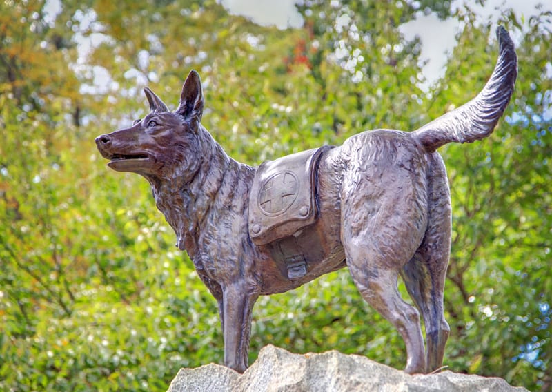
I Ride the Harlem Line - HomePosts about the trainPosts about observationsHumorous postsPosts about advertisementsPosts about eventsPosts about eventsPosts about museumsPosts with photosPosts with videosPost ArchivesRSS FeedTwitterYouTubePanoramio

Posts Tagged ‘harlem division’

Monday Morning Old Photos, Part 1 History Photos

Monday, March 7th, 2011

Have a case of the Mondays? Need something to cheer you up on this crappy weather day? Hopefully some old Harlem Division photos will do the trick. People are always selling old slides and photos on eBay, and I have a little bit of a collection. I don’t always know the location (though they are on the Harlem Division), date, or even the photographer, but I love looking back at the trains of yesteryear – and even the old cars in some of the photos. The next few Mondays I’ll be posting my collection of old eBay-acquired photos… enjoy a little look into the past on the Harlem Division.


Chatham: Revisited Train History Photos

Wednesday, December 29th, 2010

I’m not exactly sure why, but I have a strange affinity for the village of Chatham. Although it is an adorable place, rather quaint, I wonder what exactly it was like when the railroads ran through here. You might see a freight train, or a passing Lake Shore Limited, but none of them stop. Chatham once serviced the New York & Harlem Railroad, the Boston & Albany, and the Rutland – all of which are long gone. And thus the place is a little bit of a curiosity to me. The many suburbs along the Harlem – Bronxville, Hartsdale, Scarsdale, and even the ones further north, Katonah, Brewster – they were all influenced by the rail. They grew and morphed into the places we know now, and though the rail does not entirely define those places now, the rail still is there, playing a part in the futures of those areas. But Chatham, it is a special case. The single most defining factor of the village has disappeared. It is no longer the terminus of any railroads. The once busy Union Station no longer serves train riders, it is a bank. Chatham has reverted to a quieter version of itself, representing a little portion of historical Columbia County.

Many places across the country have seen transformations, with the things they were built upon playing a part in their downfall. Detroit was built on the auto industry, but as the industry migrated and moved overseas, parts of the city have become abandoned – a true example of urban decay. The small town of Centralia, Pennsylvania was built upon anthracite coal, literally and figuratively. Ironically, it was the coal brought the death sentence of the little town, as it caught fire in the 1960′s and has been burning ever since. There is something about these changed places that intrigues me (high on my list of places to visit is also Pripyat, an abandoned town brought down by the failings of humans). All of these, of course, are radical examples. Chatham lives, it does not decay. Perhaps the once-fundamental core of its being is gone, but it still thrives. But just as one can compare the photos of Detroit’s urban decay with the historical photos of yesteryear, one can bear witness to the radical changes made in just a few scant years (or slightly longer than the years I’ve been on this Earth). There are no more signal towers, water towers, or turntables. The children of Chatham will never board a passenger train in their village to head the one hundred and twenty seven miles to Grand Central. And of course, the Harlem division will never again run this far north.

The time for Chatham as a railroad town has passed. As the time has ticked by it has reinvented itself, and is still reinventing itself. It is not the decline as a railroad hub that has intrigued me about Chatham, but that reinvention. It is a charming and beautiful little village, with a gazebo, clock tower, shops, and restaurants – plus a whole lot of history. The photos below were taken back in October upon my second visit to Chatham, a visit where I actually had time to shop and eat, and enjoy the surrounding history. Perhaps if you too find Chatham to be interesting you will take the time to visit some day…


The photos below were sent in by reader John. They were taken in the late 1960′s at Chatham.


For an even further back look, the Library of Congress has an illustrated map view of the village of Chatham from 1886. At this time the “Union Station” had not been built, and the Boston & Albany, and the New York & Harlem each had their own rail stations. For easier viewing I’ve given the B&A station a slight red tint, and the Harlem a blue tint.

Tuesday Tour of the Harlem Line: Woodlawn Train Photos

Tuesday, November 30th, 2010

Although it is the Hudson Line more often cited for its scenery, you do pass by quite a few interesting locales taking a train down the Harlem Line. From the farmlands of Dutchess county, to the reservoirs that serve the city’s need for water, there is much to see on the Harlem Line – and I hope that I’ve been able to show some of this on my weekly tour of the various stations. Although it certainly isn’t the most noteworthy, the line does also pass by quite a few cemeteries. In the case of Kensico Cemetery, the railroad probably played a part in its growth. Kensico may no longer have a station dedicated to it, but at one time the cemetery even had its own rail car to serve the more affluent of folk heading to bury their loved ones.


Resting place of Gail Borden, at the Woodlawn Cemetery

Another cemetery I haven’t yet mentioned on here, however, is the Woodlawn Cemetery. Woodlawn station itself is located in the Bronx, a bit shy of 12 miles from Grand Central. It is just north of Woodlawn that the New Haven Line diverges from the Harlem. Although the station isn’t expressly for the cemetery, as Kensico was, it is very close to it. For those interested in seeing the final resting place of quite a few historical figures, Woodlawn would definitely be an interesting place to check out. Not to mention the wide array of different styles of memorial (someone please erect a statue of me riding a liger upon my death?). Some of the memorials were designed by renowned architects, such as Cass Gilbert (who designed New Haven’s Union Station), and McKim, Mead, and White (who designed the original Pennsylvania Station). Noteworthy musicians WC Handy, Miles Davis, and Duke Ellington are all buried at Woodlawn, as well as businessmen whose names most people recognize: RH Macy, JC Penney, and Frank Woolworth. And many of us would also recognize the names of Joseph Pulitzer, Fiorello LaGuardia, Simon Guggenheim, and Augustus Juilliard, also buried in the cemetery. Of course my favorite “resident” is Gail Borden, the eccentric inventor of condensed milk, who was also a Harlem Division rider (a post about him on here is quite overdue, but will be coming soon, I swear!)

Anyways, here are some shots of the Harlem Line station at Woodlawn:


Tuesday Tour of the Harlem Line: Goldens Bridge Train History Photos

Tuesday, November 16th, 2010

Of all the places I’ve been on this little tour of the Harlem Line, it is funny that I have not yet featured the one station I spend the majority of my time at. As of the first of this month, I have been living in and commuting from Goldens Bridge for two years (I’ve been commuting regularly on the Harlem Line slightly longer, though from Brewster station). Besides some of my crazy neighbors, it is a fairly nice area, albeit a little quiet.


Goldens Bridge station in the 1920′s

Over the years that the railroad has been servicing the area, much has changed in Goldens Bridge, and it was probably not as quiet as it now feels. In the early 1900′s the Muscoot Reservoir was created, flooding areas in the town that people had formerly lived. Some of these people had their entire houses moved to other locations. The construction of Interstate 684 in the late 1960′s also changed the landscape of the hamlet significantly, and the two dangerous grade crossings that were in the town have been removed. The station building that was in Goldens Bridge was on the east side of the track, roughly located where the southbound entrance to the Interstate now is.


A train at Goldens Bridge

The busy station of yesteryear is a stark contrast to what the station is now. It was from Goldens Bridge that the Mahopac branch diverged from the main line, a once-popular service which was discontinued in 1959. The station had a turntable as well as a water tower -northbound steam trains would take on water here and be set until they reached Millerton. By 1902 the New York Central had two tracks all the way up to Goldens Bridge until 1909 when the line was two-tracked up to Brewster.

For all the changes the area has gone through over the years, it does slightly amuse me that the current station is sandwiched between the concrete and asphalt of the highway on the east side, and a little bit of wilderness surrounding the reservoir to the west (if you’re interested about visiting that little bit of wilderness, I’ve posted about it before). But it is that Interstate that brings many people to the station, the parking lot is always filled with commuters from New York and Connecticut… and plenty of folks for me to people-watch…


Tuesday Tour of the Harlem Line: Croton Falls (and bonus: Millerton, Harlem Valley Rail Trail) Train Photos

Tuesday, October 26th, 2010

This week’s photo tour of the Harlem Line begins with current station Croton Falls. Located 47.7 miles north of Grand Central, it is the northernmost station in Westchester County. Prior to the arrival of the railroad, the town went by the name of Owensville, only becoming Croton Falls in 1846. The New York & Harlem Railroad had reached Croton Falls by the year 1847, and it served as the terminus of the line for a little more than a year – service to Dover Plains began by the end of 1848. By 1907 there were two tracks up to Croton Falls, as well as a siding with a capacity for 83 cars.

Today Croton Falls is a bit on the small side, with a platform long enough to accommodate only four train cars. The station area is located in the center of the hamlet, surrounded by various shops, restaurants, a post office, and the fire department.


Since I didn’t have all that many great photos from Croton Falls, here is an additional set of photos from Millerton. Millerton was once a stop on the Harlem Division, and is one of the few that still has the old station building. South of Millerton, all the way to Wassaic where it meets with Metro-North, runs the Harlem Valley Rail Trail. The trail covers the 10.7 miles where the rail once was. There is also a smaller portion of trail up by Copake, which I posted photos of a few weeks ago. If you’re interested in learning more about the Harlem Valley Rail Trail, you can view their website here.


Edna St. Vincent Millay – Poet & Harlem Division Rider History Photos

Saturday, October 9th, 2010

As riders of the train, every day we share our commute with advertisements – there are ads on the platforms, and ads in the train cars themselves. Some of the ads are interesting and well designed, and others may be lacking in that department. Over the summer I recall seeing one specific ad for Columbia County tourism. It had a picture of a young boy looking through a paper towel tube, and it urged you to visit Columbia county. No offense to the designer, but I don’t exactly know how that would lure me to visiting you – my (hypothetical) kid can look through paper towel tubes all he wants at home, thank you very much.

Columbia County is a nice rural portion of New York, and a delightful change of pace from the city life – and there is more to do than look through paper towel tubes. The Harlem Line, and several other rail lines once ran through here, but that has disappeared. Copake Lake and the Taconic State Park are both interesting nature related venues, and the county has a rich history worth exploring. The home of the eighth president of the United States, Martin Van Buren, is located in Columbia county, and is open to visitors. Though probably less known than the former president, Pulitzer-prize-winning poet Edna St. Vincent Millay also made her home in Columbia county, and portions of it are open to the public. Last weekend, on the way home from Vermont, I made a stop at her former home, which is called Steepletop.


Edna St. Vincent Millay

Edna St. Vincent Millay was born in 1892 in Rockland, Maine. From a young age she was exposed to classic literature by her mother, and began to write on her own. By the time she had entered Vassar College at 21, she had already won several awards for her poetry. After graduation from Vassar, Millay moved to New York City and lived in Greenwich Village. Her book of poetry titled Second April was published in 1921, and includes one of my favorite poems of hers:

The railroad track is miles away,
And the day is loud with voices speaking,
Yet there isn’t a train goes by all day
But I hear its whistle shrieking.

All night there isn’t a train goes by,
Though the night is still for sleep and dreaming,
But I see its cinders red on the sky,
And hear its engine steaming.

My heart is warm with friends I make,
And better friends I’ll not be knowing;
Yet there isn’t a train I wouldn’t take,
No matter where it’s going.

As much as I’d love to say that Millay wrote this poem about the Harlem Division, it was only in 1925, and after Second April was published, that she and her husband moved to Austerlitz, NY. Her home was not far from the Harlem Division’s Hillsdale Station, and she did actually ride the trains from there: a famous Harlem Division rider. Millay spent the later years of her life in Austerlitz until her death in 1950. She, along with her mother, husband, sister, and brother-in-law are buried on the property. Although the home is occasionally open for tours (and is designated a National Historic Landmark), the poetry trail which leads to her grave, is always open to the public, and where all photos below are from.


Early Harlem Line Timetables, and new timetable catalog Train History

Friday, August 20th, 2010

Quite a while ago I started up a minor project, what I called the Historical Archives. My goal was to collect as much old paper history of the Harlem Line and assemble a museum of sorts – timetables, maps, tickets, photos, and news articles – digitize it, and put it online for everyone to view, completely for free. (There are folks in the city that have better collections than I, such as the Transit Museum and the NYPL, but these are kept under lock and key, and you can’t have them unless you shell out the dollars.) Anyways, the more I added to the archives, the clunkier the directory page that listed all the entries got. I wanted to arrange it in a better way – especially the timetables. I’ve been working on just that for the past week or so, putting all the timetables in a special catalog that you can view with a short description and thumbnails. If you see something you like, you can click on it and go to the main entry for that item with a larger image. I think this is much easier.

In honor of the new catalog I thought it would be fun to show some of the earliest timetables that I have in the collection. The first is from 1871, when Cornelius Vanderbilt was still president of what was known as the New York and Harlem Railroad, with his son William Henry as vice president.


Note the first station is 26th Street, the first Grand Central Depot was only opened later in the year. At the time of publication Hartsdale was still known as Hart’s Corners, Hawthorne as Unionville, and Craryville as Bain’s. Bedford did not have the “Hills” added yet, and Purdey’s was the spelling used, as opposed to today’s Purdy’s.

The timetables below are from 1890, 1909 and 1914. The center timetable, from 1909, is important historically because at this time Grand Central Terminal was being constructed, as the older Depot was being demolished. Despite that, train service still needed to go on interrupted, and a temporary platform at Lexington Avenue was used. The timetable makes note of this on the front, directing riders to the temporary terminal.


Name evolution: After the New York and Harlem Railroad was leased to the New York Central, it was listed as the Harlem Division of the New York Central and Hudson River Railroad. Later the name was shortened to just the New York Central.

The timetables above are from 1922, 1931 and 1940 and list service to Lake Mahopac, a branch of the Harlem that diverged at Golden’s Bridge. Below are timetables from 1958 and 1964. Service on the Mahopac branch was discontinued in 1959, and so the timetable from 1958 is one of the last to list that service.

Not long after that 1964 timetable the New York Central merged with the Pennsylvania Railroad to form the Penn Central. Although the service was not the best, in my opinion the Penn Central had some of the nicer timetables in the collection. But that is a post for another Friday. Enjoy the day, and the weekend everyone!

As an additional note, I thank the Danbury Railway Museum’s library for giving me access to their collection of timetables to digitize. If anyone out there has some timetables that I don’t have listed, I would love it if you could contact me and send me a scan so I can add it into the catalog.

Former Terminus of the Harlem Line: Chatham, Then and Now Train History Photos

Friday, July 16th, 2010

Several months ago I was amused when I saw a blog linking to my own, and they referred to me as a “closeted rail fan.” Despite “coming out” and accepting the title I still wonder if it is really an appropriate term to call me. I certainly like riding on trains, but I know very little about the physical machine that is a train. I think my primary interest is the history, and most specifically, how technology affected places and people. And I think it is undeniable that the railroads played a big part in how New York evolved. Back when Cornelius Vanderbilt bought the land for the original Grand Central Depot, the location was considered “the boonies,” as City Hall was thought of as the northern end of the city. And what would Westchester County be like without the rail? The rail encouraged the people of the area to move north and spread out, turning the rural areas into the suburbs we know today.

I think another thing that interests me about the rail is the abandonment. I really don’t know why, but I have a fascination with abandoned places – and the rail has plenty of them. The railroad was once the primary way mail and freight was delivered, and how people got around. But cars became increasingly more popular, and with the advent of the interstate system, cars took the place of trains in getting around. And so stations were closed, rail lines cut, and railroad companies went bankrupt. I do mention it frequently on here, but the Harlem Line is no stranger to abandonment. In 1972 passenger service north of Dover Plains ceased, and around 50 miles worth of track, all the way to Chatham, was abandoned.


Old photos and postcards of Chatham, NY

In the grand scheme of things, Chatham was luckier than most. It was once a thriving area for transportation: the Harlem Division, Rutland Railway, and the Boston and Albany all made stops. Though the Harlem and Rutland’s track has been ripped out, CSX and Amtrak still use the Boston and Albany track, running through the quiet village without stopping. Quite a few of the former stations on the Harlem Division have really nothing to see… station buildings long gone and mostly forgotten. But as I said before, Chatham was luckier than most, the historical Union Station still stands, restored and used as a bank. And in 1974 it was placed on the National Register of Historic Places.


Henry Hobson Richardson was an influential architect in the 19th century, popularizing a style of architecture that was named for him: Richardsonian Romanesque. The revival style incorporated 11th and 12th century European Romaneque traits. Although Trinity Church in Boston was his most notable work, he designed several railroad stations for the Boston and Albany. Several architects trained with Richardson, including Charles McKim and Stanford White, who designed the original Pennsylvania Station, though in the Beaux-Arts style. Following Richardson’s style, however, were two others that worked for him: George Shepley and Charles Coolidge. Their firm Shepley, Rutan and Coolidge, based in Boston, completed Richardson’s partially completed and pending projects, one of which was Chatham’s Union Station. In total, the firm completed 23 of B&A’s stations, including Boston’s South Station, still in use by the MBTA.

Chatham’s Union Station opened on August 31, 1887. The ticket office in the station was closed in 1960, and pieces of the inside, including the waiting benches, were sold off. Passengers used the station up until it’s final closure in March of 1972, ending the many years it served as the terminus of the Harlem Division. The station has been restored, and reopened in 1999. It is now the office for the Chatham branch of the Bank of Kinderhook. And it is still quite beautiful… one of the few remaining vestiges of the Upper Harlem Line that I can actually see.

Friday’s From the Historical Archive: Old Maps and Station Names Train History

Friday, April 9th, 2010

Some of the very first things that were added when I created the Historical Archives were maps I found thanks to the Library of Congress. It was interesting to see the network of railroads in the country grow in size exponentially through the 1800′s, and then later in the mid 1900′s crash and quite a few disappeared. There was one map, however, that caught my attention.

That map lists a station along the Harlem Line: Golding’s Bridge. Was it a typo? In the back of my mind I had always wondered about the apostrophe thing. Is Goldens Bridge written properly with an apostrophe, or without? And now, a new question. What is Golding’s Bridge? For whom was the town named, and does the bridge still exist? Why are other stations on this map, or other maps also listed with apostrophes? Brewster’s, Pawling’s? The map also lists quite a few stations that have different names today, such as Hart’s Corners, Whitlockville, and Bains.

In my endeavor to find the answer to at least the apostrophe question, I consulted with the town historian of Lewisboro, of which Goldens Bridge is a part of. She unfortunately told me that she could only “add to the confusion.”

I’m not exactly sure where the original bridge that gave your hamlet its name first stood, but it spanned the Croton River, which is now under the reservoir. The bridge may have belonged to a gentleman called Golding, Goulding, or Colden. I have heard all of these names. That bridge had to have been an important crossing to get to what is now Somers, and points west. It most certainly dates to the Revolution or before.

In 2003, Metro North dropped the apostrophe from the name of the station. Almost all official timetables and signage refer to the station as Goldens Bridge. However, old signage with the apostrophe does still exist. The station listing on M-7 trains still has the apostrophe. Most official town signage also does not have the apostrophe. However the Fire Department for the town still uses it. Google maps still uses it. It is a name still in transition.

Many towns and names along the Harlem Line went through similar transitions. Spellings were changed, apostrophes were dropped. Brewster’s and Pawling’s are both evidence of that. Some names changed completely. So let’s take a little tour through the area and see how some of these names came to be, shall we?

Bronx – Named for Jonas Bronck, who purchased the land in 1639. Originally known as The Bronck’s, in reference to the family, at some point over time the spelling evolved into the current form.
Mott Haven – Named for Jordan Mott, who had an ironworks that opened in 1828. He purchased the land from the Morris family.
Morrisania – Named for the Morris family. Lewis Morris was a signer of the Declaration of Independence. Gouverneur Morris was also a prominent member of that family.
Woodlawn – Originally two words, but was condensed into one by 1870.
Mount Vernon – Named for George Washington’s home. Original name was Hunt’s Bridge.
Fleetwood – Named for the ancestral home of John Stevens.
Scarsdale – Named for the ancestral home of Caleb Heathcote.
Hartsdale – Named after Eleazar Hart, who donated the land. Was previously known as Hart’s Corners.
Bedford Hills - Originally named only Bedford, the Hills was added to the name in 1910.
Katonah – Had several previous names, first was Mechanicsville. Later changed to Whitlockville in 1830, for the Whitlock family. Later renamed Katonah from the native word Ketatonah, which translates to Great Mountain.
Purdys – Named for Daniel Pardieus, his grandson Isaac donated the land to the railroad in 1844.
Brewster – Named for brothers James and Walter Brewster, and at the time was known as Brewster’s.
Dykemans – Named for Joseph Dykeman.
Patterson – Named for Matthew Paterson, older maps list the name with only one ‘t’
Pawling – Named for the Paulding (possibly Pauling) family.
Wingdale – Named for the Wing family. Jackson Wing operated an Inn which opened in 1806. Previous names include Wing’s Station, and South Dover.
Harlem Valley – Wingdale - Harlem Valley comes from the name of the railroad (New York & Harlem). Used to be two stops, State Hospital (actual name of the hospital was Harlem Valley State Hospital) and Wingdale (mentioned above). Wingdale station was eliminated, and later Metro-North combined the two and the name.
Millerton – named for Sydney G. Miller, who was an engineer and contractor for the construction between Dover Plains and Chatham.
Craryville – Named for Peter Crary. Station was previously known as Bains, or Bains Corners for hotel owner Peter Bain.
Martindale – Named for John Martin.
Philmont – Previous name was Phillips Mountain, but was later condensed into Philmont. Named for George Phillips, who built a dam and a mill in the area.
Chatham – Named for Lord Pitts, Earl of Chatham, England.

That list does not mention every station on the current Harlem Line, or the rail line in the past. I am specifically mentioning stations that were named after people, or had a name change of some sort. Apostrophes in names often originated because the land was named after, or originally belonged, to a specific family or person.

Harlem Line Historical Archives Train History

Sunday, January 24th, 2010

If you are an astute observer, you may have noticed several weeks ago that a new link appeared over on the right of the site, entitled the Harlem Line Historical Archives. Basically, I thought it would be kind of cool to scan a bunch of my old collected timetables, and to put up my digital collection of timetables (most of them I do not have hard copies of). Now that the collection online has over 40 pieces, mostly timetables, as well as a few maps, I thought I would sort of “announce” it. And now you will notice, there is now an image on the right side of the site referencing the archives.

Anyways, note that this is a work in progress. Currently you can view the archives only by chronological order. In the future I’d like to implement additional features, so you can search the archives by viewing thumbnail images, or by keywords. Keyword searching is only partially implemented, I can keyword entries from the back-end, but as of currently, you can’t really search through the keywords (although some may show up in the tag cloud on the lower right of the site). I suppose it is an interesting challenge for myself, because I’ve already had to write some minor things in PHP to get the collection working as it is (such as the handy previous and next links you get while viewing pages).

Outside of learning a bit of PHP for myself, the other thing I love is looking at all this printed material in chronological order. And the way the timetables have evolved visually over the years, from the New York & Harlem days, to New York Central, Penn Central and beyond. My personal favorites are the two Penn Central timetables above, both from the late 1960′s, with the groovy typography. It would be awesome in the future to acquire a timetable for every year, and to do a timetable evolution video or something. Which just reminded me, if you have any timetables, maps, items of interest that you digital versions of and would like to donate/share/let me use, please let me know… especially if they are from a year that I don’t currently have.

Enter the Harlem Line Historical Archives

PS- I swear, I am working on something really awesome for the site. Another little mini-project. Here is a hint: it is a flash based mini-game. If you do not see it by the end of the week, I urge you to harass me about it, and when the heck I am going to be finishing it.