
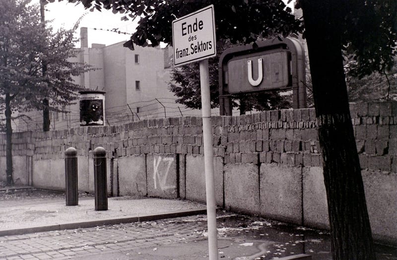
I’ve always said that my primary interest in railroads is not necessarily the machine that is a train, but instead the way railroad systems change over time, and how they influence the people and locations around them – or even how places influence the rails. For those with similar interests, the city of Berlin is a great case study. As I’m sure everyone is familiar, Germany and the city of Berlin were partitioned after World War II into areas occupied by the French, British, Americans, and Soviets. The Soviet portion became the German Democratic Republic, better known as East Germany, and the three other sectors the Federal Republic of Germany, better known as West Germany. In Berlin, a transit system that once spanned the entire city became truncated by this political divide. With the construction of the Berlin wall, starting in 1961, the city became truly divided.
Ghost station: The U-Bahn station Bernauer Straße was closed after the construction of the Berlin Wall. Here you can see the entrance to the station, blocked by the wall. The station was reopened after the reunification of Germany. Photo taken August 27, 1962 by Allhails.
The citywide network of trains in Berlin struggled to conform to the divisions forced upon it by politics. In some instances, stations were completely closed, and lines were truncated as to not operate in the opposite sector. In other situations, lines were able to operate across the border, albeit with restrictions. The U8 line, for example, started in West Germany, but traversed a portion of East German territory before returning to the west. Although the train was permitted to pass through East Germany, they were not permitted to stop at the stations there. Shrouded in darkness and heavily guarded, these shuttered stations became colloquially known as “ghost stations.” In a unique situation, Friedrichstraße railway station, located in East German territory, was open to citizens from both sides of the border, though the station was divided into isolated sections for each.
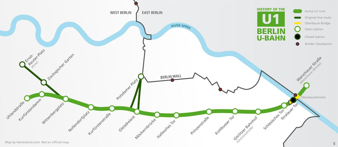
Map showing the history of the U1 line, and the Berlin Wall.
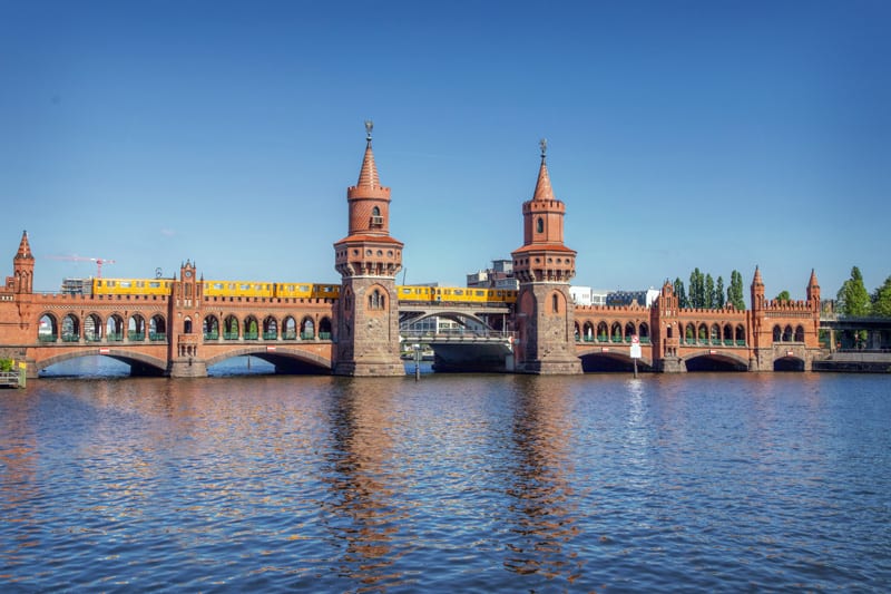
It seems appropriate that our first photographic foray into Germany focuses on the first line of the U-Bahn, the U1. The U in U-Bahn stands for Untergrund, but there are many instances where the lines are anything but. One place that seems to epitomize the “not underground” Underground is the Oberbaumbrücke, or Oberbaum Bridge. First opened in 1896, the bridge carried pedestrians, cars, and eventually trains over the River Spree. The first train ran from Stralauer Tor, a station established on the viaduct, to Potsdamer Platz. Eventually the line was extended to Knie (now known as Ernst-Reuter-Platz) in the west, and Warschauer Brücke (now Warschauer Straße) in the east.
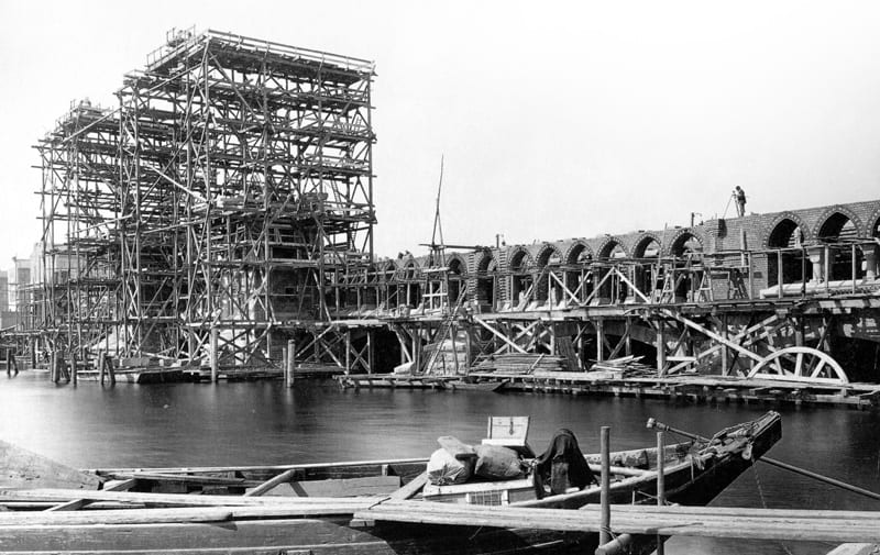
1885 construction photo of the Oberbaum Bridge. Photo by German photographer Hermann Oskar Rückwardt.
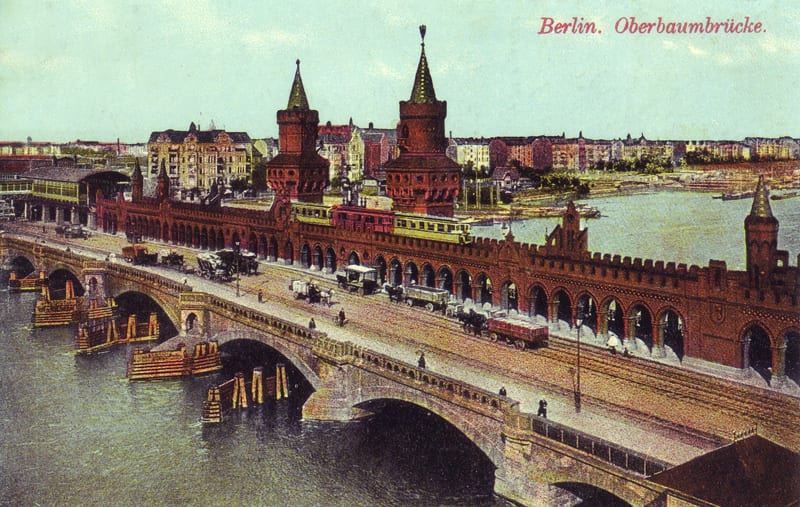
Postcard showing the Oberbaum Bridge and the original Stralauer Tor station, circa 1910.
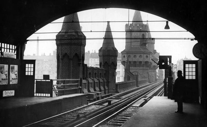
Looking out toward the bridge from Osthafen station, 1932. Photo via the Bundesarchiv.
The route of the line has stayed fairly consistent over the years, though Potsdamer Platz, Zoologischer Garten, and Ernst-Reuter-Platz are now part of the U2 line. Stralauer Tor station, which was on the bridge viaduct, was damaged during World War II and never rebuilt. After the partition of Germany, the Oberbaum Bridge connected the American sector with the Soviet sector, and the bridge became a border checkpoint, allowing West German pedestrians to cross. Beyond the border was Warschauer Brücke, the only station on the line located in East Berlin. For the duration that the Berlin Wall stood, the station was closed, truncating the line at the border. It was reopened in 1995 under the name of Warschauer Straße.
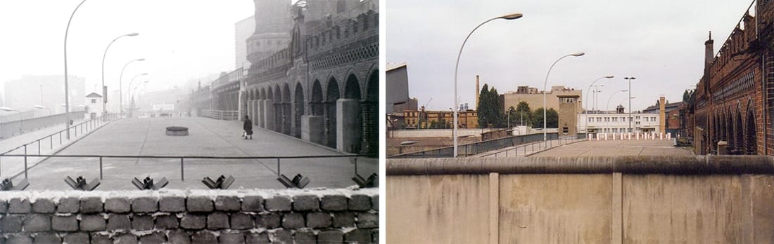
Progression of the Berlin Wall, alongside the Oberbaum Bridge – Photo at left taken December, 1964 by Allhails. Photo at right from 1984 by WhitePrince.
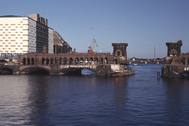
The Oberbaum Bridge in rough shape in 1993. Photo by Roehrensee.
The Oberbaum Bridge itself is quite a beautiful bit of architecture, and is a fairly photogenic landmark. The name literally translates to “Upper tree bridge” in English, a reference to a previous wooden bridge that stood nearby. Despite being heavily damaged at multiple points through history, it was never completely demolished. During World War II the Nazis bombed the center of the bridge to prevent the Soviet army from crossing. Though the East Germans made minimal repairs to the the bridge after the war (at least enough for pedestrians to cross), it was not truly restored to its original grandeur until after the German reunification. Spanish architect Santiago Calatrava designed the steel center portion of the bridge, while the rest was restored much as it looked originally. The bridge was reopened for cars and pedestrians in 1994, and subway traffic in 1995.
Anyway, here is a collection of some photos of the U-Bahn and the Oberbaum Bridge. Over the next few weeks we’ll be visiting some more interesting spots in Berlin, including a few more “not underground” Underground stations.

 Â
  Â
  Â
  Â
  Â
  Â
  Â
  Â
  Â
  Â
  Â
  Â
 
The German eagle and the Berlin bear adorn the towers.
Nice pics. I’ll be in Germany in July, first time. Will be very interested to ride the U and S Bahns in Munich, and if time permits, the ICE.
Munich has a wonderful S and U system, but don’t forget it’s trams, as well! It’s the best way to get to know the city. ICE’s are abundant, but not all lines are fast. From Munich, it’s ‘only’ 250 kph to Augsburg, and 200 kph to Rorbach, halfway to Ingolstadt. If you want faster, you need to travel to Nuremberg, between Ingolstadt and Nuremberg the line is capable of 300 kph running. By ICE, it’s only 1h10 to get to Nuremberg, a lovely city, with lots of history, and a heck of a train station. Munich’s HBF (Hauptbahnhof, means main station) pales in comparison, I’m afraid.
You did a poor Job concerning the picture captions: One of the says “Looking out toward the bridge from Warschauer Brücke station, 1932” when it clearly is the station “Osthafen” which is nonexistent anymore. Another one is supposed to be a “1985 construction photo” whereas it should be 1885.
No need to be rude. The obvious typo has been corrected. The label for the other photo comes directly from the Bundesarchiv… the short title of the photo is actually “Berlin, Bahnhof Warschauer Strasse” – whether correct or not.